Hurricane Milton becomes major Category 3
The Florida Keys are under a tropical storm watch as Hurricane Milton continues strengthening on its way to Florida’s Gulf Coast.
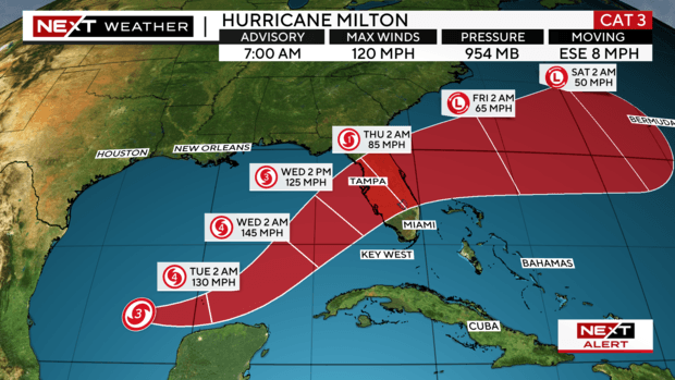
Milton strengthened into a Category 3 hurricane Monday morning. The storm is expected to intensify further into a Category 4 hurricane later Monday in the central Gulf.
The National Hurricane Center said Milton is then expected to encounter a much less favorable environment with strong shear and dry air entrainment. Some weakening is anticipated before the hurricane reaches Florida’s Gulf coast. The most likely path suggests it could make landfall in or near the Tampa Bay area on Wednesday.
Gov. Ron DeSantis declared a state of emergency in 35 counties on Saturday ahead of Milton’s expected landfall. In the state of emergency bulletin, DeSantis included Broward, Miami-Dade, and Monroe Counties. That number has since increased to 51 counties.
According to the National Hurricane Center, Milton is forecast to move east-southeastward to eastward for the next 36 hours or so, followed by a turn toward the northeast at a faster forward speed. It is expected to speed up and intensify between Monday and Tuesday.
Parts of Florida are under storm surge and hurricane watches. The National Hurricane Center issued a hurricane watch for Florida’s Gulf coast from Chokoloskee to the mouth of the Suwanee River, including Tampa Bay, as well as for the Dry Tortugas. A storm surge watch was issued for the Gulf coast from Flamingo northward to the Suwannee River, including Charlotte Harbor and Tampa Bay.
A tropical storm watch is in effect for the Lower, Middle, and Upper Florida Keys, including Florida Bay, as well as for the Gulf coast from Flamingo to south of Chokoloskee and for the Gulf coast north of the mouth of the Suwanee River to Indian Pass.
Dangerous storm surge is expected, the hurricane center said. Tampa Bay, as well as the Anclote River to Englewood, Florida, could see storm surge as high as 12 feet. Charlotte Harbor and the area from Yankeetown to the Anclote River, as well as the area from Englewood to Bonita Beach, could see as much as 10 feet of surge. Bonita Beach to Chokoloskee could see up to 7 feet, while the Suwannee River to Yankeetown could get up to 5 feet of storm surge.